Sentinel-1 reveals shifts from Morocco earthquake
Following the devastating earthquake that struck Morocco on 8 September, satellite data have been made available through the International Charter ‘Space and Major Disasters’ to help emergency response teams on the ground.
In addition, radar measurements from Europe’s Copernicus Sentinel-1 satellite mission are being used to analyse how the ground has shifted as a result of the quake, which will not only help in planning the eventual reconstruction but will also further scientific research.
The powerful 6.8 magnitude earthquake struck the Atlas Mountains, about 75 km from Marrakech, in the late evening of Friday 8 September. It occurred in a region that lies along the fault lines of the European and African tectonic plates – but, nonetheless, it was a rare event for western Morocco.
Unfortunately, the quake claimed thousands of lives, caused buildings and homes to collapse and blocked roads. It even caused buildings to sway as far away as the country's northern coast.
On behalf of the International Federation of Red Cross and Red Crescent Societies, the United Nations Institute for Training and Research triggered the International Charter ‘Space & Major Disasters’.
Through the Charter, Earth observation assets from different space agencies are combined so that satellite images of areas struck by extreme events can be provided as fast as possible to define and map the extent of the disaster and hence help teams in their rescue efforts.
Satellites routinely monitoring Earth from space and delivering data to support rapid damage mapping offer a unique tool to aid disaster management.
Since a single space agency or satellite operator alone cannot meet the demands of disaster management, ESA and France’s CNES space agency initiated the International Charter Space and Major Disasters in 1999.
The Copernicus Emergency Mapping Service was also activated to help share satellite data in response to the Moroccan earthquake in line with the operational cooperation that is in place with the International Charter.
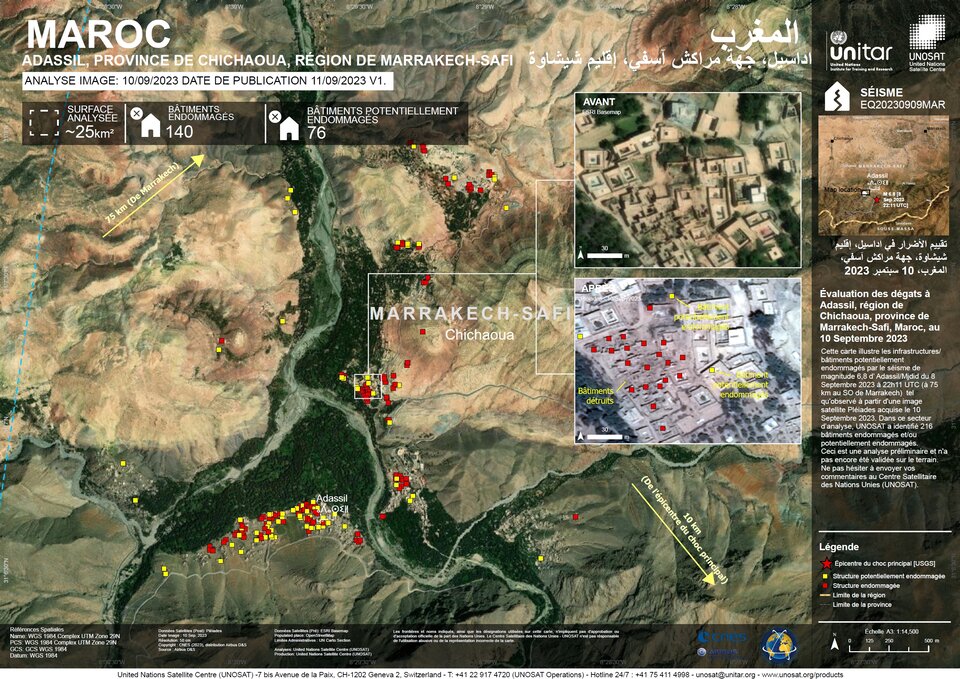
So far, images from the French Pléiades very high-resolution satellites have been used to generate detailed damage maps over the affected areas. Pléiades is also part of ESA's Third Party Mission programme.
The first damage mapping products were released on 11 September, and more followed.
These maps, such as that shown above, can be used by rescuers to decide on the best course of action, by identifying which roads to take and which bridges to avoid in case of collapse, for example.
Philippe Bally, ESA representative of the International Charter, said, “Clearly time is of the essence when disaster strikes. Via the Charter and the Copernicus Emergency Mapping Service, it is part of our job to help ensure that the appropriate satellite data is delivered to help relief efforts.”
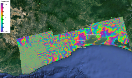
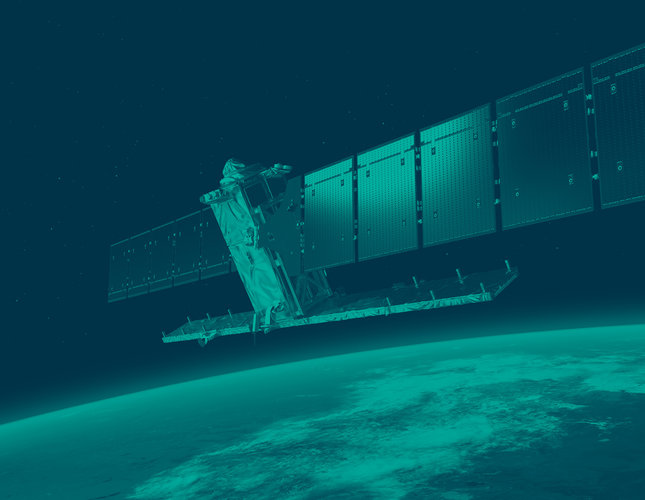
While the response to Morocco’s disaster is ongoing, scientists are using measurements from the Copernicus Sentinel-1 mission in a technique known as ‘interferometry’ to compare before-and-after views of the region.
The Copernicus Sentinel-1 mission carries a radar instrument that can sense the ground and can ‘see’ through clouds, whether day or night.
Among the mission’s many uses, it routinely traces subtle changes in elevation of Earth’s surface. When an earthquake occurs, changes to the surface are obviously more pronounced than gradual subsidence or uplift.
These radar images allow scientists to observe and analyse the exact effects that earthquakes have on the land surface.
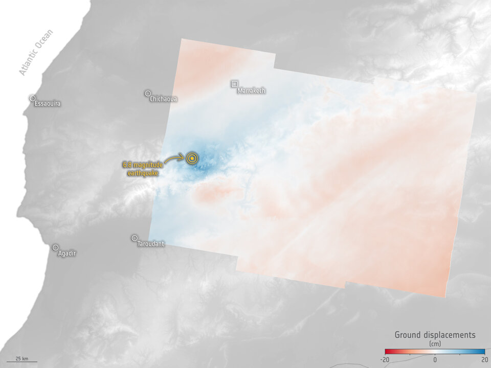
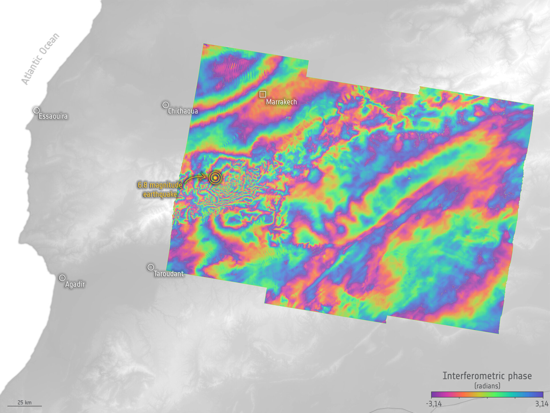
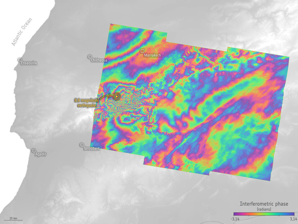
In the case of the Moroccan earthquake, Sentinel-1 data have been combined to measure surface displacement that occurred between an acquisition on 30 August and one after the earthquake on 11 September.
This has led to an interferogram that shows a colourful ‘fringe’ pattern and allows scientists to understand more about the nature of the quake and the risk of further hazards in the future.
Dr Bally explained, “Immediately after Sentinel-1 had acquired data over the earthquake area, the Earth observation processing chains available in the user community allowed information on terrain deformation to be to be retrieved.
“This is the case with the interferogram generated in an automated and rapid fashion by the UK-based COMET LiCSAR, and with the Geohazard Exploitation Platform using the DIAPASON InSAR service of the CNES French space agency.
“Precise deformation maps are generated for geohazard science purposes and can be used to advise disaster response teams concerning the hazard event.”
ESA’s Director of Earth Observation Programmes, Simonetta Cheli, noted, “The Charter and the Copernicus Emergency Mapping Service are extremely valuable tools to support vital relief efforts when disaster strikes.
“Satellites orbiting Earth are unique in their ability to not only providing wide views of affected areas but also very detailed information as we have seen here provided by the Pléiades mission.
“Since the Copernicus Sentinel-1 mission carries a radar, it can see through clouds so is also often used for mapping serious floods. In the case of the Moroccan earthquake, the mission’s value has been to measure how the surface has shifted, which will be important once the immediate crisis is over, and restoration can start.”