Earth from Space: Quebec province
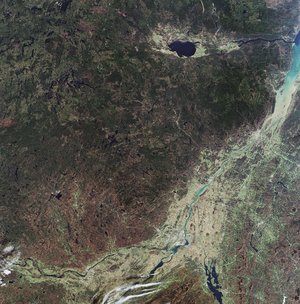
This Envisat image features the southern part of Canada’s Quebec province, which occupies a territory nearly three times the size of France.
The mighty Saint Lawrence River is visible flowing from the southwest to the northeast. Beginning from Lake Ontario (not visible), the river flows northeast past Montreal (visible as the whitish area at the confluence of the two rivers) and Quebec City (the whitish area visible on the north bank of the river) to the Gulf of St. Lawrence.
Saint Lawrence River is 1197 km long and its drainage basin covers some 1 million km², of which 505 000 km² is in the United States. The river, which connects the Great Lakes with the Atlantic Ocean, is the primary drainage of the Great Lakes Basin.
Quebec City is the capital of the province of Quebec. The Laurentian Mountains lie to the north of the city.
The dark blue lake visible at the top right of the image is Lac Saint-Jean, which is situated some 170 km north of the Saint Lawrence River. It covers an area of 1003 km² and is relatively shallow at 63 m deep.
Lac Saint-Jean is fed by dozens of small rivers and discharges through two outlets into the Saguenay River (visible), which then drains Lac Saint-Jean into the St. Lawrence River at Tadoussac, some 190 km northeast of Quebec City.
This image was acquired by Envisat's Medium Resolution Imaging Spectrometer (MERIS) instrument on 26 October 2007, working in Full Resolution mode to provide a spatial resolution of 300 metres.