
Types of orbits
Our understanding of orbits dates back to Johannes Kepler in the 17th century. Europe now operates a family of rockets at Europe’s Spaceport to launch satellites to many types of orbit.
What is an orbit?
An orbit is the curved path that an object in space (such as a star, planet, moon, asteroid or spacecraft) takes around another object due to gravity.
Gravity causes objects in space that have mass to be attracted to other nearby objects. If this attraction brings them together with enough momentum, they can sometimes begin to orbit each other.
Objects of similar mass orbit each other with neither object at the centre, whilst small objects orbit around larger objects. In our Solar System, the Moon orbits Earth, and Earth orbits the Sun, but that does not mean the larger object remains completely still. Because of gravity, Earth is pulled slightly from its centre by the Moon (which is why tides form in our oceans) and our Sun is pulled slightly from its centre by Earth and other planets.
During the early creation of our Solar System, dust, gas, and ice travelled through space with speed and momentum, surrounding the Sun in a cloud. With the Sun being so much larger than these small bits of dust and gas, its gravity attracted these bits into orbit around it, shaping the cloud into a kind of ring around the Sun.
Eventually, these particles started to settle and clump together (or ‘coalesce’), growing ever larger like rolling snowballs until they formed what we now see as planets, moons, and asteroids. The fact that the planets were all formed together this way is why all the planets have orbits around the Sun in the same direction, in roughly the same plane.

When rockets launch our satellites, they put them into orbit in space. There, gravity keeps the satellite on its required orbit – in the same way that gravity keeps the Moon in orbit around Earth.
This happens in a way that is similar to throwing a ball out of the window of a tall tower – to get the ball going, you need to first give it a ‘push’ by throwing it, making the ball fall towards the ground on a curved path. Whilst it is your throw that gives the ball its initial speed, it is gravity alone that keeps the ball moving towards the ground once you let go.
In a similar fashion, a satellite is put into orbit by being placed hundreds or thousands of kilometres above Earth’s surface (as if in a very tall tower) and then being given a ‘push’ by the rocket’s engines to make it start on its orbit.
As shown in the figure, the difference is that throwing something will make it fall on a curved path towards the ground – but a really powerful throw will mean that the ground starts to curve away before your object reaches the ground. Your object will fall ‘towards’ Earth indefinitely, causing it to circle the planet repeatedly. Congratulations! You have reached orbit.
In space, there is no air and therefore no air friction, so gravity lets the satellite orbit around Earth with almost no further assistance. Putting satellites into orbit enables us to use technologies for telecommunication, navigation, weather forecast, and astronomy observations.
Launch to orbit
Europe’s family of rockets operate from Europe’s Spaceport in Kourou, French Guiana. On each mission, a rocket places one or more satellites onto their individual orbits.
The choice of which launch vehicle is used depends primarily on the mass of the payload, but also on how far from Earth it needs to go. A heavy payload or a high altitude orbit requires more power to fight Earth’s gravity than a lighter payload at a lower altitude.
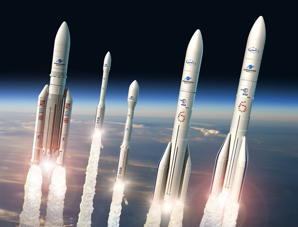
Ariane 5 is Europe’s most powerful launch vehicle, capable of lifting one, two, or multiple satellites into their required orbits. Depending on which orbit Ariane 5 is going to, it is able to launch between approximately 10 to 20 tonnes into space – that is 10 000—20 000 kg, which is about the weight of a city bus.
Vega is smaller than Ariane 5, capable of launching roughly 1.5 tonnes at a time, making it an ideal launch vehicle for many scientific and Earth observation missions. Both Ariane 5 and Vega can deploy multiple satellites at a time.
ESA’s next generation of rockets includes Ariane 6 and Vega-C. These rockets will be more flexible and will extend what Europe is capable of getting into orbit, and will be able to deliver payloads to several different orbits in a single flight – like a bus with multiple stops.
Types of orbit
Upon launch, a satellite or spacecraft is most often placed in one of several particular orbits around Earth – or it might be sent on an interplanetary journey, meaning that it does not orbit Earth anymore, but instead orbits the Sun until its arrival at its final destination, like Mars or Jupiter.
There are many factors that decide which orbit would be best for a satellite to use, depending on what the satellite is designed to achieve.
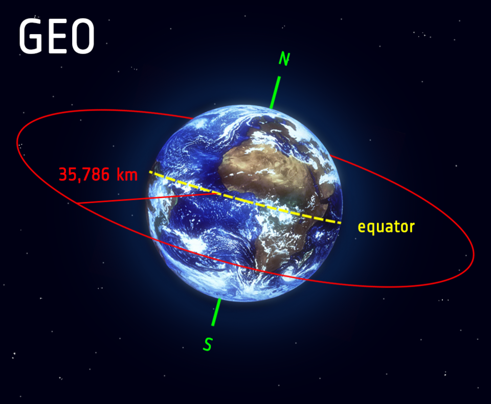
Geostationary orbit (GEO)
Satellites in geostationary orbit (GEO) circle Earth above the equator from west to east following Earth’s rotation – taking 23 hours 56 minutes and 4 seconds – by travelling at exactly the same rate as Earth. This makes satellites in GEO appear to be ‘stationary’ over a fixed position. In order to perfectly match Earth’s rotation, the speed of GEO satellites should be about 3 km per second at an altitude of 35 786 km. This is much farther from Earth’s surface compared to many satellites.
GEO is used by satellites that need to stay constantly above one particular place over Earth, such as telecommunication satellites. This way, an antenna on Earth can be fixed to always stay pointed towards that satellite without moving. It can also be used by weather monitoring satellites, because they can continually observe specific areas to see how weather trends emerge there.
Satellites in GEO cover a large range of Earth so as few as three equally-spaced satellites can provide near global coverage. This is because when a satellite is this far from Earth, it can cover large sections at once. This is akin to being able to see more of a map from a metre away compared with if you were a centimetre from it. So to see all of Earth at once from GEO far fewer satellites are needed than at a lower altitude.
ESA’s European Data Relay System (EDRS) programme has placed satellites in GEO, where they relay information to and from non-GEO satellites and other stations that are otherwise unable to permanently transmit or receive data. This means Europe can always stay connected and online.
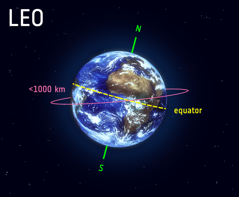
Low Earth orbit (LEO)
A low Earth orbit (LEO) is, as the name suggests, an orbit that is relatively close to Earth’s surface. It is normally at an altitude of less than 1000 km but could be as low as 160 km above Earth – which is low compared to other orbits, but still very far above Earth’s surface.
By comparison, most commercial aeroplanes do not fly at altitudes much greater than approximately 14 km, so even the lowest LEO is more than ten times higher than that.
Unlike satellites in GEO that must always orbit along Earth’s equator, LEO satellites do not always have to follow a particular path around Earth in the same way – their plane can be tilted. This means there are more available routes for satellites in LEO, which is one of the reasons why LEO is a very commonly used orbit.
LEO’s close proximity to Earth makes it useful for several reasons. It is the orbit most commonly used for satellite imaging, as being near the surface allows it to take images of higher resolution. It is also the orbit used for the International Space Station (ISS), as it is easier for astronauts to travel to and from it at a shorter distance. Satellites in this orbit travel at a speed of around 7.8 km per second; at this speed, a satellite takes approximately 90 minutes to circle Earth, meaning the ISS travels around Earth about 16 times a day.
However, individual LEO satellites are less useful for tasks such as telecommunication, because they move so fast across the sky and therefore require a lot of effort to track from ground stations.
Instead, communications satellites in LEO often work as part of a large combination or constellation, of multiple satellites to give constant coverage. In order to increase coverage, sometimes constellations like this, consisting of several of the same or similar satellites, are launched together to create a ‘net’ around Earth. This lets them cover large areas of Earth simultaneously by working together.
Ariane 5 carried its heaviest 20-tonne payload, the Automated Transfer Vehicle (ATV), to the International Space Station located in low Earth orbit.
Medium Earth orbit (MEO)
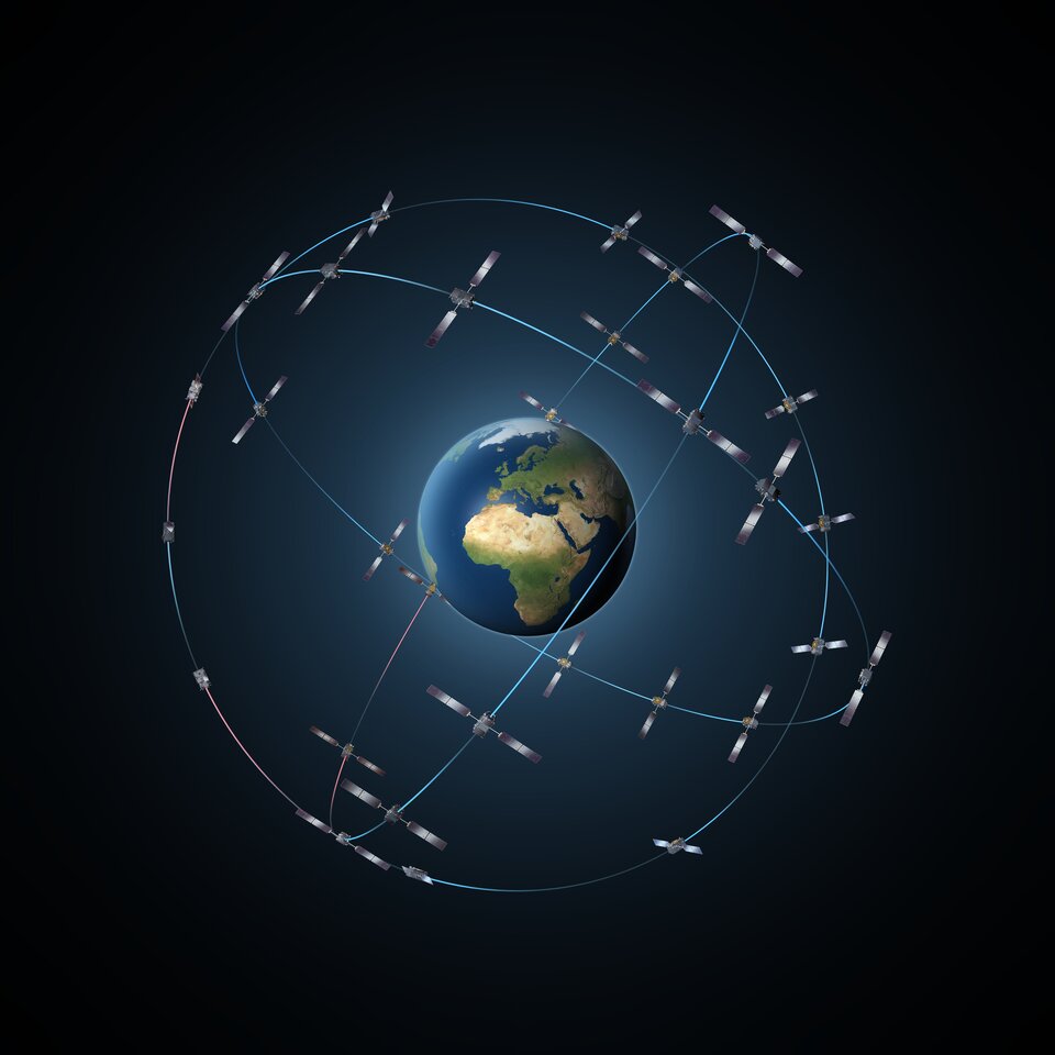
Medium Earth orbit comprises a wide range of orbits anywhere between LEO and GEO. It is similar to LEO in that it also does not need to take specific paths around Earth, and it is used by a variety of satellites with many different applications.
It is very commonly used by navigation satellites, like the European Galileo system (pictured). Galileo powers navigation communications across Europe, and is used for many types of navigation, from tracking large jumbo jets to getting directions to your smartphone. Galileo uses a constellation of multiple satellites to provide coverage across large parts of the world all at once.
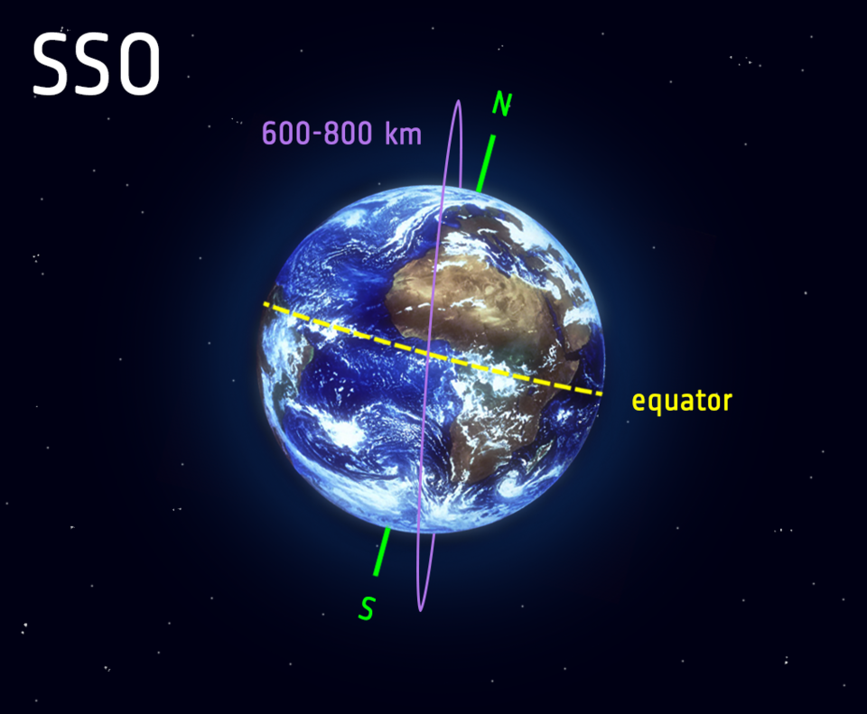
Polar orbit and Sun-synchronous orbit (SSO)
Satellites in polar orbits usually travel past Earth from north to south rather than from west to east, passing roughly over Earth's poles.
Satellites in a polar orbit do not have to pass the North and South Pole precisely; even a deviation within 20 to 30 degrees is still classed as a polar orbit. Polar orbits are a type of low Earth orbit, as they are at low altitudes between 200 to 1000 km.
Sun-synchronous orbit (SSO) is a particular kind of polar orbit. Satellites in SSO, travelling over the polar regions, are synchronous with the Sun. This means they are synchronised to always be in the same ‘fixed’ position relative to the Sun. This means that the satellite always visits the same spot at the same local time – for example, passing the city of Paris every day at noon exactly.
This means that the satellite will always observe a point on the Earth as if constantly at the same time of the day, which serves a number of applications; for example, it means that scientists and those who use the satellite images can compare how somewhere changes over time.
This is because, if you want to monitor an area by taking a series of images of a certain place across many days, weeks, months, or even years, then it would not be very helpful to compare somewhere at midnight and then at midday – you need to take each picture as similarly as the previous picture as possible. Therefore, scientists use image series like these to investigate how weather patterns emerge, to help predict weather or storms; when monitoring emergencies like forest fires or flooding; or to accumulate data on long-term problems like deforestation or rising sea levels.
Often, satellites in SSO are synchronised so that they are in constant dawn or dusk – this is because by constantly riding a sunset or sunrise, they will never have the Sun at an angle where the Earth shadows them. A satellite in a Sun-synchronous orbit would usually be at an altitude of between 600 to 800 km. At 800 km, it will be travelling at a speed of approximately 7.5 km per second.
Transfer orbits and geostationary transfer orbit (GTO)
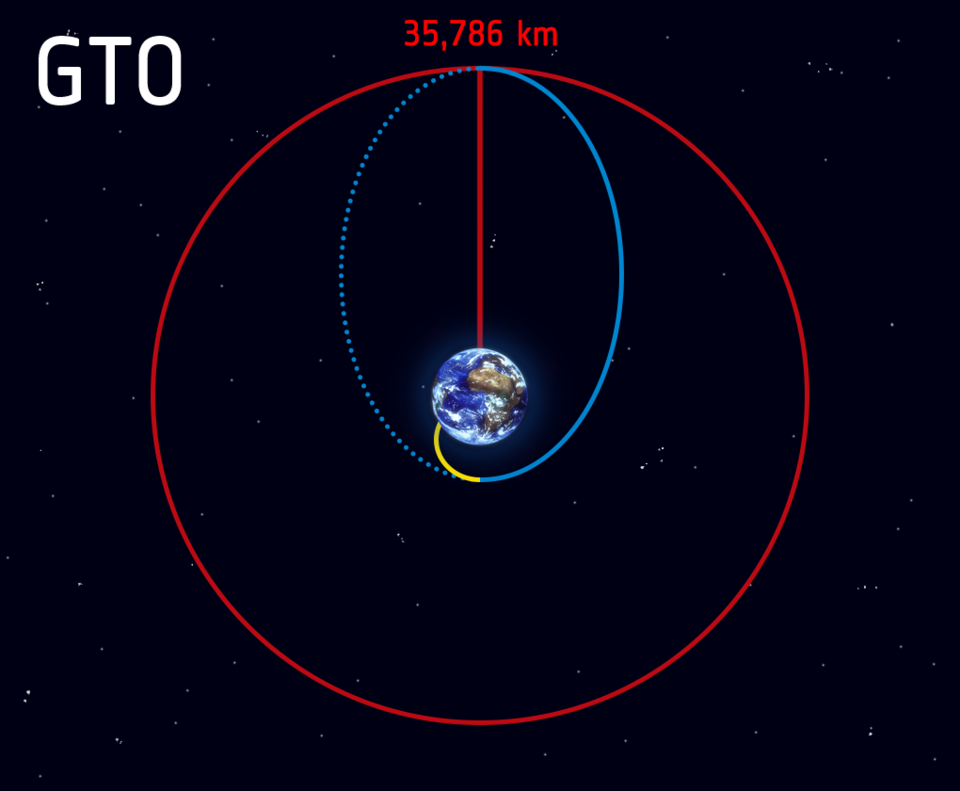
Transfer orbits are a special kind of orbit used to get from one orbit to another. When satellites are launched from Earth and carried to space with launch vehicles such as Ariane 5, the satellites are not always placed directly on their final orbit. Often, the satellites are instead placed on a transfer orbit: an orbit where, by using relatively little energy from built-in motors, the satellite or spacecraft can move from one orbit to another.
This allows a satellite to reach, for example, a high-altitude orbit like GEO without actually needing the launch vehicle to go all the way to this altitude, which would require more effort – this is like taking a shortcut. Reaching GEO in this way is an example of one of the most common transfer orbits, called the geostationary transfer orbit (GTO).
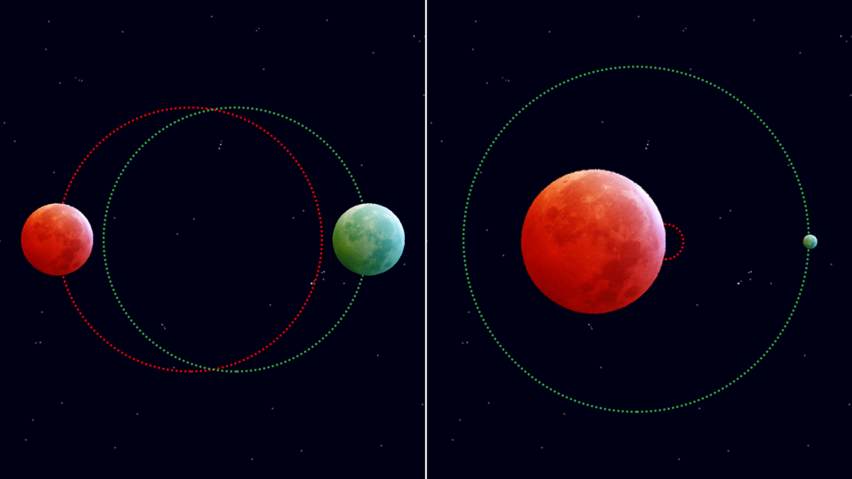
Orbits have different eccentricities – a measure of how circular (round) or elliptical (squashed) an orbit is. In a perfectly round orbit, the satellite is always at the same distance from the Earth’s surface – but on a highly eccentric orbit, the path looks like an ellipse.
On a highly eccentric orbit like this, the satellite can quickly go from being very far to very near Earth’s surface depending on where the satellite is on the orbit. In transfer orbits, the payload uses engines to go from an orbit of one eccentricity to another, which puts it on track to higher or lower orbits.
After liftoff, a launch vehicle makes its way to space following a path shown by the yellow line, in the figure. At the target destination, the rocket releases the payload which sets it off on an elliptical orbit, following the blue line which sends the payload farther away from Earth. The point farthest away from the Earth on the blue elliptical orbit is called the apogee and the point closest is called the perigee.
When the payload reaches the apogee at the GEO altitude of 35 786 km, it fires its engines in such a way that it enters onto the circular GEO orbit and stays there, shown by the red line in the diagram. So, specifically, the GTO is the blue path from the yellow orbit to the red orbit.
Lagrange points
For many spacecraft being put in orbit, being too close to Earth can be disruptive to their mission – even at more distant orbits such as GEO.
For example, for space-based observatories and telescopes whose mission is to photograph deep, dark space, being next to Earth is hugely detrimental because Earth naturally emits visible light and infrared radiation that will prevent the telescope from detecting any faint lights like distant galaxies. Photographing dark space with a telescope next to our glowing Earth would be as hopeless as trying to take pictures of stars from Earth in broad daylight.
Lagrange points, or L-points, allow for orbits that are much, much farther away (over a million kilometres) and do not orbit Earth directly. These are specific points far out in space where the gravitational fields of Earth and the Sun combine in such a way that spacecraft that orbit them remain stable and can thus be ‘anchored’ relative to Earth. If a spacecraft was launched to other points in space very distant from Earth, they would naturally fall into an orbit around the Sun, and those spacecraft would soon end up far from Earth, making communication difficult. Instead, spacecraft launched to these special L-points stay fixed, and remain close to Earth with minimal effort without going into a different orbit.
The most used L-points are L1 and L2. These are both four times farther away from Earth than the Moon – 1.5 million km, compared to GEO’s 36 000 km – but that is still only approximately 1% of the distance of Earth from the Sun.
Many ESA observational and science missions were, are, or will enter an orbit about the L-points. For example, the solar telescope SOHO and LISA Pathfinder at the Sun-Earth L1 point; Herschel, Planck, Gaia, Euclid, Plato, Ariel, JWST, and the Athena telescope are or will be at the Sun-Earth L2 point.