Mapping the world’s forests
Using satellite radar data, scientists have created a global map that quantifies the amount of wood in our forests – a key to understanding Earth’s carbon cycle and, ultimately, climate change.
Forests play a crucial role in Earth’s carbon cycle. In general, forests are ‘carbon sinks’ as they absorb and store carbon dioxide from the atmosphere. Forests that are logged or burnt down, however, release parts of the stored carbon into the atmosphere.
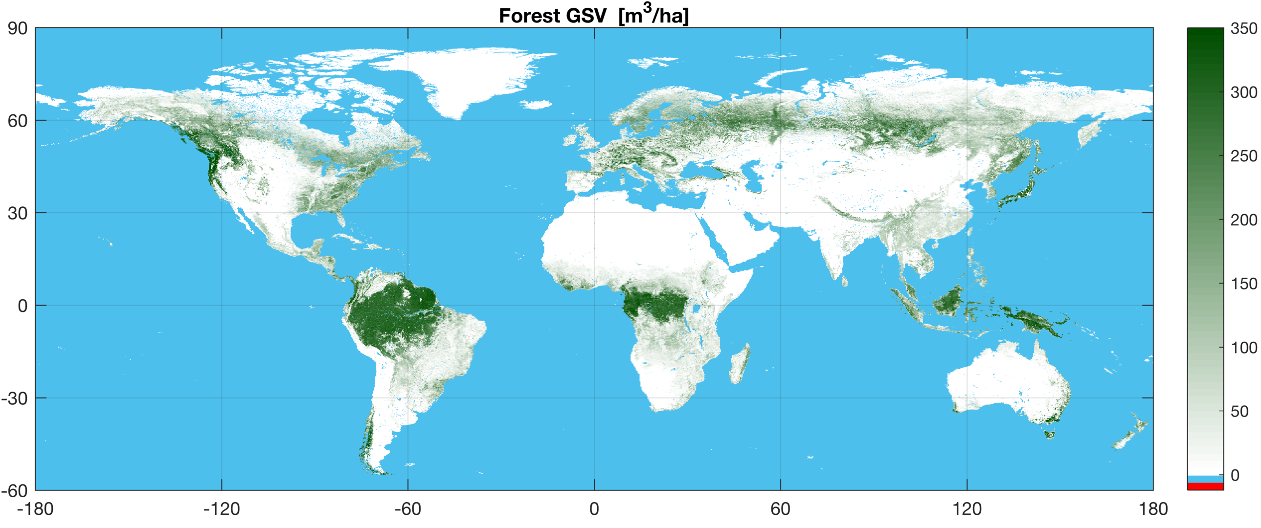
To understand the carbon cycle better, scientists use forest carbon stock estimates from Earth observation data. One of the parameters for these estimates is ‘growing stock volume’, which describes how many cubic metres of wood are estimated per hectare. Stock volume represents above-ground carbon and is thus one of the most important variables in the global carbon cycle.
Foresters use this information to estimate the commercial value of an area, while scientists use it for climate modelling.
The first consistent global map of growing stock volume for 2010 was presented last week at the GlobBiomass Final User Consultation meeting held at the UN Food and Agriculture Organization’s headquarters in Rome, Italy.
ESA’s GlobBiomass project is paving the way for a synergistic Earth observation approach to the operational monitoring of carbon stocks globally. The project exploits archived radar and optical data – including data from the Sentinel fleet of satellites – to develop new algorithms in cooperation with expert teams from across the globe.
“The GlobBiomass results represent state-of-the-art Earth observation methodologies for forest biomass mapping,” said Chris Schmullius of Friedrich-Schiller University in Jena, Germany.
“For the first time, optical and radar data have been synergistically investigated on regional and global scales to prepare operational monitoring with the ESA Sentinel-fleet.”
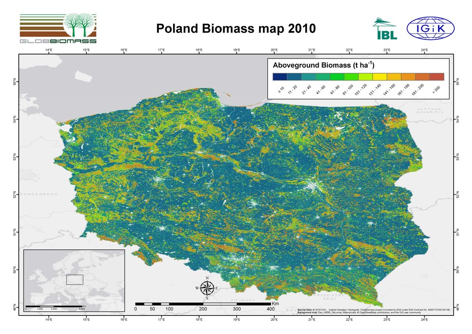
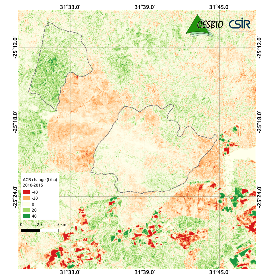
In addition to the global map, the team presented forest biomass maps and change indicators for five regions. For example, the impact of land management on biomass in the South African woody savannah between 2005 and 2015 was observed.
“After three years of intense work and discussions, we have great confidence on the spatial distribution of our biomass estimates worldwide,” said Maurizio Santoro from Gamma Remote Sensing.
“Validation at multiple scales is ongoing to confirm such impressions. Global estimates of forest growing stock volume and above-ground biomass including uncertainties will be open to the public in early 2018.”
Biomass as an Essential Climate Variable will be addressed in a future project within ESA’s Climate Change Initiative in 2018.
“Looking to the future, the delivery of multiyear retrievals from ESA’s future Biomass satellite mission will provide a unique opportunity to study the changes in forest carbon storage and, in the long term, its links to changes in climate,” said Thuy Le Toan from CESBIO in France.
The GlobBiomass project is part of ESA’s Earth Observation Data User Element.