Mars Express Frequently Asked Questions (FAQs)
About Mars Express
Where does the name ‘Mars Express’ come from?
Mars Express is so called because, at the time, it was built more quickly than any other comparable planetary mission. Mars Express's design and development phase took about five years, compared with about ten years for previous similar missions.
Where did the lander name ‘Beagle 2’ come from?
The Mars Express lander – Beagle 2 – was named after the ship on which Charles Darwin sailed around the world when formulating his ideas about evolution.
What are the mission objectives? What scientific return do you expect from the orbiter?
From orbit, Mars Express is scanning the surface and atmosphere of the planet with seven instruments. In particular it is:
- searching for signs of water down to a few kilometres underground;
- mapping the Martian surface more accurately than any other previous mission (in colour and stereo);
- determining the detailed composition of the surface;
- determining the composition and circulation of the atmosphere;
- studying the interaction of the solar wind with the planet.
Click here for more detailed information on Mars Express instruments.
What makes the Mars Express special?
Mars Express is special because, at the time of its arrival, it was performing the most detailed and complete exploration of Mars ever. For instance, Mars Express is the first mission to conduct a thorough search for water on the Red Planet: from several kilometres below the ground, and up into the atmosphere. Mars Express is searching for traces of present or past life on Mars. No other mission had attempted to do that since the historic Viking missions, more than 25 years ago.
Mars Express is also special because of the new managerial approach being used. This new approach included the re-use of existing hardware and instruments, and allowed a quicker and more cost-effective development of the mission. At the time of its development, Mars Express was built at a much lower cost than other comparable planetary missions, without compromising reliability and quality. This has been very important for ESA, since the same streamlined development method was also adopted for Venus Express, and other recent and future missions.
Mars Express is European and that makes it special, too. Mars Express is not only the first European mission to Mars, but also the first planetary mission operated entirely by Europe.
Why is it relevant for Europe to go to Mars?
With Mars Express, Europe is building its own expertise in many fields. This ranges from the development of science experiments and new technologies – new for European industries – to the control of a planetary mission. (See also the end of previous question).
Why did we decide to go to Mars again to look for water and life?
The questions about water and life are open issues, and therefore very relevant scientific questions. However, obtaining a global view of the planet is equally important. Even more important for us all on Earth, studying Mars has one obvious advantage. It can help us find an alternative home in a possible future where Earth may not longer be able to offer conditions for human life to prosper.
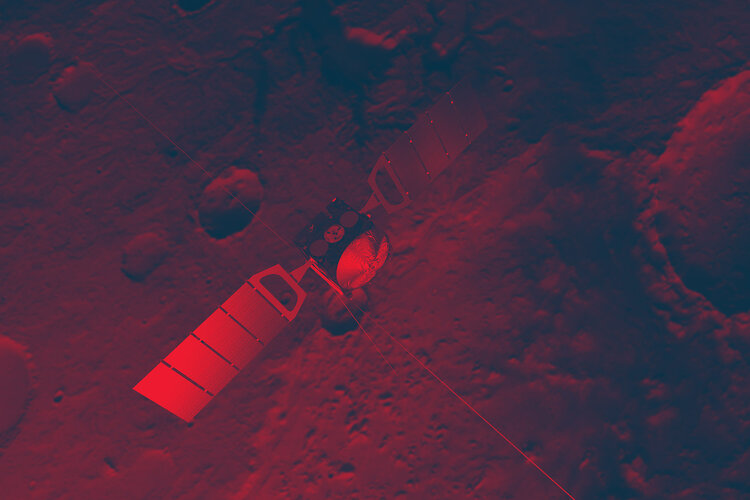
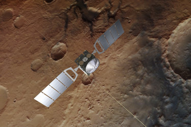
What kind of journey did Mars Express make?
Mars Express went ‘straight’ to Mars – without any ‘fly-bys’ – and started orbiting the planet.
How long did it take to get to Mars? How many kilometres did Mars Express travel?
The cruise took just over six months. Mars Express travelled at an average speed of about 10 kilometres per second and covered a distance of about 400 million kilometres.
When did Mars Express arrive at Mars, and what happened to Beagle 2?
Mars Express reached Mars at the end of December 2003. Six days before entering into orbit around Mars, Mars Express ejected the Beagle 2 lander. The orbiter was inserted into orbit around Mars on 25 December 2003. The Beagle 2 lander failed to make radio contact shortly after it was due to land on Mars on Christmas Day. Various attempts were made to contact the lander. The Beagle 2 Management Board met in London on 6 February 2004 and, following an assessment of the situation, declared Beagle 2 lost. However, in 2015, the lost lander was found in images taken by NASA’s Mars Reconnaissance Orbiter.
How long will the spacecraft be operating?
Mars Express’s orbiter was initially planned to operate for a whole Martian year (687 Earth days). The mission was then extended until end-October 2007 then May 2009. Almost 20 years after launch, Mars Express is still going strong and delivering incredible data!
What does Mars Express add to the flotilla of other international missions to Mars? Is ESA in competition with NASA?
Mars Express is complementary to all other mission to Mars. We established a deep collaboration with the (unsuccessful) Japanese Nozomi mission. We also help NASA with the transmission of data and NASA helps us. ESA is not competing with NASA.
Aren’t there already enough missions that have gone, or will go, to Mars?
Although Mars has attracted more missions than any other planet, there are still a lot of questions that need answering.
What happens to the orbiter after the mission is over?
The Mars Express orbiter will simply keep orbiting the planet for at least 50 years. Then it will probably burn up in Mars’s atmosphere. This will also ensure that debris will not pollute the planet’s surface.
Is Mars Express returning images of Mars? Are they available in real-time? Who are they forwarded to and who is exploiting them?
Mars Express is certainly producing high-quality images. The images, like all data, first go to the instruments’ scientific teams for the necessary processing and scientific analysis. After a period of six months from the moment the image have been collected, the images can be made available to the public. In some cases, the images can be made available to the public before the end of the six-month period.
Is there new technology which has been developed for Mars Express?
No. However, European industries have gained expertise in new areas such as building a complex planetary mission, including a lander. They have developed their own technology, as well as building on work done by others.
Is this technology likely to be re-used?
Many Mars Express elements were already used for Venus Express. ESA's Aurora programme, which also includes a landing on Mars, will certainly benefit from the expertise gained with Mars Express.
Is NASA involved in Mars Express?
NASA scientists are deeply involved in one of Mars Express’s instruments, the radar MARSIS.
Will space agencies share the data, for example from ESA's Mars Express orbiters and NASA rovers?
There is not an agreed exchange of data, but several European experiments are on board the rovers. The science teams will probably exchange data.
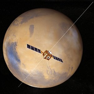
I am interested in making or obtaining a scale model of Mars Express. Do you have information on who might be constructing them?
ESA commissions scale models of its science spacecraft from professional modelmaking companies. They are produced in limited batches and are not generally available to the public as they are used in exhibitions, presentations and museums. They range in size and price (from 500 Euros to several thousand Euros for the larger ones).
An alternative might be the model of Mars Express available to download from ESA.
About images and the High Resolution Stereo Camera (HRSC)
What can the images from the Mars Express HRSC tell us?
The HRSC is the first fully functional stereo camera in the history of planetary research. Computer animations enable its images to be turned and tilted, so that the observer has a real feeling of dashing about over the surface of the planet.
The 3D pictures enable exact reproductions of the relief. This, in turn, enables scientists, for the first time, to make a detailed examination of the altimetry of the Martian surface, to calculate the slope of the valleys, study the layer formation and calculate the masses of mountains.
In short, the images provide important data for the geomorphological and geological interpretation of the surface of Mars.
How do the Mars Express HRSC pictures get back to Earth?
Before the HRSC team can lay their hands on the pictures, the data have to make the long journey back home. After the pictures are taken and stored on board Mars Express, the data is transmitted to ESA’s New Norcia Station in Australia, or to NASA’s Deep Space Network Station in Madrid. From there, the data are collected at the European Space Operations Centre (ESOC) at Darmstadt in Germany. They are then transmitted to the German Aerospace Research Establishment (DLR) in Berlin, where most of them will be processed into the pictures we see.
How long does it take to process pictures, and why?
It usually takes between four and seven days for a picture to be ‘ready’. Depending on the picture size, analysis objective and the amount of computer capacity available, this period can easily stretch to ten to fourteen days. These techniques are still very new and recently gained knowledge and experience has often meant that more-expensive picture processing is required.
In general, one orbit of Mars produces an image with a length of over 250 000 lines, sometimes more, sometimes less. The calculations required and combination of the channels takes a lot of computing time. All new images have to be released by the Principle Investigator to the Co-Investigators, and then are prepared for release to the media and the public – this can take up to a week per image.
What are the green/blue patches we see in some of the images?
The colour of the greenish patches in Gusev crater in the first image released of this site is not correct. Unfortunately, an early version of Gusev image was released before the colour had been adjusted finally to be closer to true colour as the human eye would see it in a non-dusty atmosphere of Mars.
The early version of this image was replaced by a newly computed version with proper colours where the patches are grey to black with a blue tint. This is close to what a human eye would see under normal atmospheric conditions. Currently it is not easy to get true colours of the Martian landscape because Mars is very dusty and the scenes were taken with high sun angles. The scattering of light caused in these atmospheric and lighting conditions, by the dust in the atmosphere acting as tiny red filters, means that you see the surface with a diffuse reddish glow with somewhat fuzzy appearance.
Are the colour photographs processed?
Yes, the images have been processed but that is quite normal. We are not taking colour photographs, we have to combine the different colour channels which requires processing time. Each of the four colour channels operate with a filter of different wavelength (red, green, blue and infrared) and produce data sets which have to be combined and calculated on to a digital elevation model.
The colour channels are absolutely real, but they do not reflect the true colour as we would see it with our eyes. These views can be obtained by processing the data, which does not mean ‘faking’ the colours, but fitting them to standard spectral curves which we know. We adjust the obtained colour image data to a standard spectral curve derived from Earth-based observations in terms of wavelength and intensity.
If we have dust, haze or other atmospheric conditions, various wavelengths get partially filtered. Obviously, images get more blurry and some colours become more dominant. Sun-exposed slopes reflect or absorb light in a different way to dark slopes or dark material (such as dark spots of possible sediments seen in some images).
The main limitation, of course, is that from orbit we do not have any colour adjustment possibilities as for example, the NASA rovers. They have colour references mounted on their rovers and even they have problems matching their colours.
Are the HRSC images ‘doctored’ in any way?
No, the images are not ‘doctored’. We use standard techniques for radiometric and geometric calibration but this is not ‘doctoring’. Nobody wants to see the raw image data as they are received, but even these will become accessible to the public, normally after six months. If, by chance, we received images suffering from, for example, ‘salt and pepper’ effects, or oversaturated pixels, they are ‘recovered’ using filter techniques from standard systematic processing procedures. These techniques have been used since the early days of image processing.
Did Mars Express HRSC take pictures of the so-called ‘face’ in the Cydonia region?
Yes.
The Mars Express orbiter was not in a suitable position to collect images of Cydonia area until late in 2004. Until then, Mars Express was able to observe closely only southern latitude features. Planetary scientists are interested in Cydonia because it is part of the boundary between highland and lowland areas.
Mars Express did cover this area on 1 April 2004 (orbit 262), 29 December 2004 (orbit 1216), 1 January 2006 (orbit 2533) and 6 April 2006 (orbit 2872), but it was not possible to obtain images of high enough quality due to factors such as the swath width at that location, resulting in poor ground resolution and atmospheric distortion during data acquisition, heavily reducing data quality.
The next encounter was on 22 July 2006 (orbit 3253). HRSC parameters were set to get the best possible data quality for nadir and both stereo channels. Luckily, unpredictable atmospheric phenomena such as clouds or dust over the target area did not limit or prevent acquisition of high quality data for Cydonia, now public.
To view the Cydonia images obtained by Mars Express click here.
When the orbiter arrived over a suitable position in the northern hemisphere, it used its High Resolution Stereo Camera in the course of its planned and routine mapping of the surface, but not specifically to study any ‘face-like’ features. The mesas of Cydonia are of interest to planetary scientists, but they were not a priority for observations. These images are being used to look at the geological formations in this region to see where water once flowed, as some scientists think the northern plains are all that is left of an ancient Martian ocean.
Twenty five years ago, NASA's Viking 1 spacecraft was circling Mars, taking photographs of possible landing sites for its twin, Viking 2, when it spotted the shadowy likeness of a human face in the region of the Red Planet called Cydonia. The ‘Face on Mars’ became a popular icon. It has starred in films and appeared in books and magazines for 25 years! Some people thought the ‘face’ is real evidence of life on Mars.
Although most scientists did not believe the face was an alien artifact, photographing Cydonia became a priority for NASA’s Mars Global Surveyor when it arrived at the Red Planet in 1997. In April 1998, Mars Global Surveyor flew over Cydonia for the first time and took a high-resolution photograph, ten times sharper than the original Viking pictures. It revealed a natural landform, there was no alien monument after all.
But not everyone was satisfied, because the camera on board Mars Global Surveyor had to peer through wispy clouds to see the surface. Perhaps, the sceptics said, alien markings were hidden by haze. In 2001, Mars Global Surveyor drew close enough for a second look and captured an extraordinary photograph using maximum resolution. Each pixel in the 2001 image represented 1.5 metres, compared to 43 metres per pixel in the best Viking image from 1976.
The picture showed a feature called a ‘mesa’, like the landforms common in western USA. The Cydonia region is littered with many mesas like this, but which do not look like human heads and they attract little popular attention. Subsequent laser altimetry scans, with height measurements made to within 20 to 30 centimetres, confirm that its shape and all of its dimensions are similar to the other mesas and not exotic in any way.
Humans on Mars
Do you think it will be feasible to send people to Mars in the short-term?
Perhaps in 15–20 years time. There is still a lot for us to learn before we send people there.
If people go to Mars how will they get there, and would it be possible for me to go?
There is still a lot for us to learn before we send people, and no one yet knows the best way to get to Mars. ESA's Terrae Novae exploration programme is leading Europe's human journey into the Solar System. As the International Space Station demonstrates, it takes much time and effort from many people to turn designs into working spacecraft in orbit.
Decisions are required to ensure long-term European capabilities for example in low-Earth orbit and to prepare the next steps in deep space for lunar surface exploration and intermediate steps towards sending humans to Mars. The Terrae Novae 2030+ strategic roadmap was developed to steer the long-term vision for Europe’s decision makers on the robotic and human exploration of the Solar System.
The overarching vison of Terrae Novae is for Europe to step-up further and enter the top tier in selected exploration areas with a sustained lunar exploration campaign building on the first European astronaut to the Moon surface before 2030, and Europeans on their way to Mars by 2040 while keeping European presence and use of low-Earth orbit.
Landing humans on Mars will very likely be some kind of multinational effort, but other experts say that it might be within the ability of one prosperous nation like the United States, if getting to Mars has a very high priority. The cost of such a venture has been estimated at 6000 million US dollars or more. An increasingly popular idea is to send unpiloted vehicles in stages to provide equipment and a way for the people who would land later to get home. This approach would avoid the difficulty of developing one giant ship with equipment and supplies for a round trip.
The first landing would be a spaceship that would be a return vehicle. It would land intact, so it could take off again, but it would have used up its fuel. Supply and mining and processing vessels would follow. The humans would arrive last. They would dig for subsurface water and other materials they could convert into fuel for the trip home.
If you want to be a European astronaut, it would be a good idea to study subjects like maths, physics, chemistry or biology at school. Some astronauts are also test pilots in the air force of their country so, if you have an interest in flying and engineering, that might help. Try to keep fit, take part in sports and team games, as astronauts have to get on very well with all kinds of people, often in very difficult conditions. You could learn another language as this will be very important on international missions.
Click here for more information on how to be an ESA astronaut.